
Low water levels in Danube River beginning to affect food supply and energy in large parts of Europe
Thank you for choosing Automatic Translation. Currently we are offering translations from English into French and German, with more translation languages to be added in the near future. Please be aware that these translations are generated by a third party AI software service. While we have found that the translations are mostly correct, they may not be perfect in every case. To ensure the information you read is correct, please refer to the original article in English. If you find an error in a translation which you would like to bring to our attention, it would help us greatly if you let us know. We can correct any text or section, once we are aware of it. Please do not hesitate to contact our webmaster to let us know of any translation errors.
The severe drought along the Danube River is beginning to affect transport, food supply, and energy systems across Europe. Water levels have dropped so low that cargo ships must reduce loads, slowing transport of grain, fuel, and industrial goods. This creates bottlenecks for countries that rely on the Danube as a major trade corridor.
The drought also threatens agriculture, since the river is a key source of irrigation water. Lower flows reduce cooling capacity for power plants, including nuclear facilities, and limit hydropower production, increasing pressure on Europe’s energy grid during an already strained summer.
Experts warn that if water levels continue to fall, Europe could face higher food prices, supply chain delays, and energy shortages, with ripple effects across several EU member states.
Further Reading:
Scientific paper on Droughts in South East Europe (SEE): current picture, tendencies and impact: https://nhess.copernicus.org/articles/26/1305/2026/?
Photo Credit:
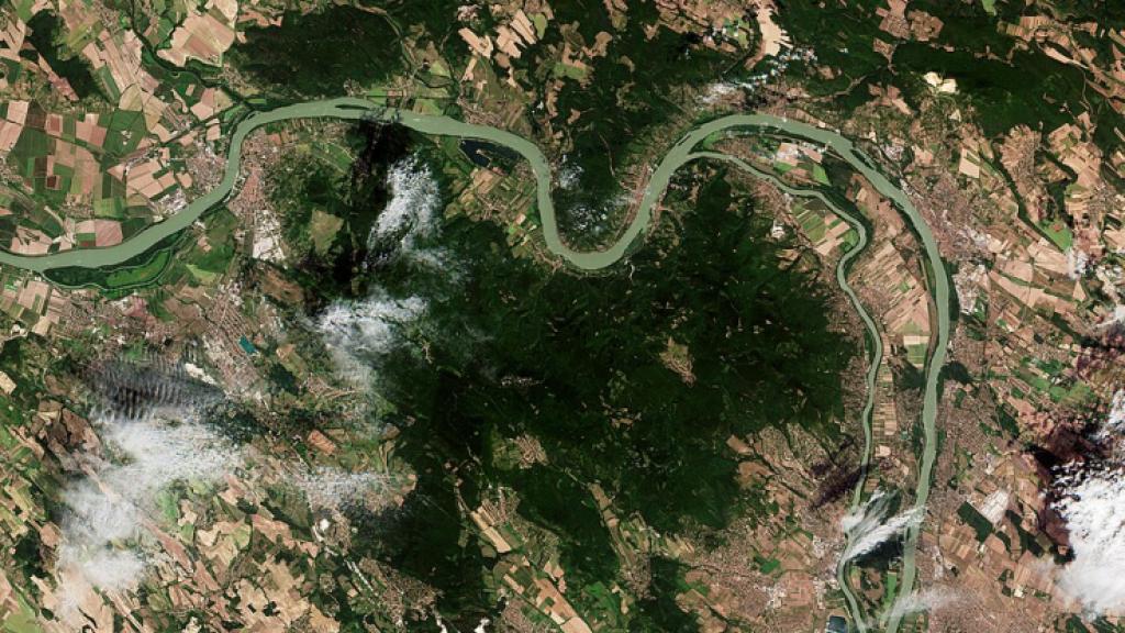
Danube’s waters fall to record lows ESA524550 - The Danube River near Budapest.jpg

These Copernicus Sentinel-2 images show a stretch of the Danube river about 45 km north of the Hungarian capital, Budapest.
See more images to compare: https://commons.wikimedia.org/w/index.php?search=Low+water+levels+in+Danube&title=Special%3AMediaSearch&type=image
This year the Danube’s low waters have caused energy and water shortages in and around Budapest as well as problems for river barges and ferries. The low levels of water also impact wildlife, with fish unable to survive as water temperatures and pollution concentration levels rise while oxygen levels decline.
The Danube is the European Union’s longest river and flows for 2860 km from Germany to the Black Sea. Record low levels have also been reported in Romania.
contains modified Copernicus Sentinel data (2025/26), processed by ESA
Attribution: Danube’s waters fall to record lows ESA524550 - The Danube River near Budapest.jpg Copy
[[File:Danube’s waters fall to record lows ESA524550 - The Danube River near Budapest.jpg|Danube’s_waters_fall_to_record_lows_ESA524550_-_The_Danube_River_near_Budapest]]
7 August 2026 (upload date) - Taken on 9 August 2025